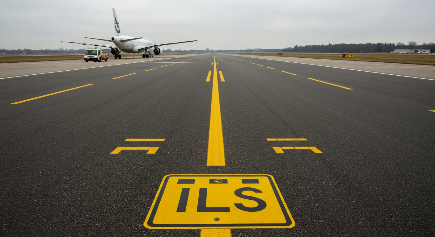
What is the ILS Critical Area Sign?
The ILS Critical Area Sign—featuring bold “ILS” lettering on a red background—marks the boundary of a zone where vehicles or aircraft could potentially disrupt Instrument Landing System signals. Positioned strategically alongside taxiway holding markings, this sign has a counterpart: the exit sign, which features yellow backing with crisp black text.
This protected zone encompasses the ILS antennas—both localizer and glideslope—protecting signal integrity. The sign serves as an important warning, warning pilots and ground crews that their presence within this space could compromise the precision guidance signals that guide approaching aircraft safely to the runway.
Importance of the ILS Critical Area
The ILS critical area protects aviation operations, safeguarding signal integrity when it matters most. Any aircraft or vehicle entering this protected zone can interfere with on radio transmissions, causing signal distortion that could endanger for incoming flights.
Why is this so important? During final approach and landing—aviation’s most unforgiving phase—signal interference can provide inaccurate guidance and dangerous approach paths. In low-visibility conditions, such disruption becomes extremely dangerous.
Think of this critical area as a protected zone around localizer and glideslope antennas, where vehicles and aircraft are strictly forbidden during ILS operations. Beyond this lies an even larger “sensitive area”—a broader protective zone that becomes essential during low-visibility autoland operations, when signal precision is essential for safe landings.
How ILS Signals Work
The Instrument Landing System operates through two sophisticated components working together:
Aircraft instruments decode these signals accurately, translating radio waves into visual guidance cues that enable stabilized approaches even when visibility plummets. However: interference with either component can render this guidance dangerously unreliable, making the protection of critical areas essential for aviation safety.
When to Hold Short of the ILS Critical Area
An important point: pilots must hold short of the ILS critical area only when Air Traffic Control explicitly commands it. This isn’t a blanket rule—it’s conditional, triggered by specific operational circumstances and weather conditions.
ATC typically issues these hold-short instructions when an aircraft conducting an ILS approach has passed the Final Approach Fix, and weather conditions deteriorate below an 800-foot ceiling or visibility drops under 2 miles.
At non-towered airports, the responsibility shifts to pilots themselves. They must exercise judgment and maintain clearance from the critical area whenever an aircraft is conducting an instrument approach within two miles of the threshold—but only when weather falls below those same 800-foot ceiling or 2-mile visibility thresholds.
In good weather conditions. Holding short generally isn’t required when visibility is clear or no aircraft are executing ILS approaches. However, pilots must always: pilots must always comply with ATC instructions to ensure the safety of aircraft depending on ILS guidance.
Weather Conditions Affecting ILS Operations
Weather is the main factor that determines when ILS critical areas demand protection. As visibility deteriorates, pilots rely more on instrument guidance—making signal integrity essential.
When visibility drops very low—such as Category II or III ILS approaches—the requirements become more stringent. These conditions trigger more stringent protective measures, often expanding coverage to include the larger ILS sensitive area.
Seasonal challenges create additional challenges. Snow accumulation and torrential rain can significantly affect signal propagation, increasing the need for area protection.
Markings and Dimensions of the ILS Critical Area
The ILS critical area announces itself through a distinctive ladder-like pattern painted across the taxiway—an unmistakable visual cue consisting of two solid yellow lines connected by pairs of perpendicular yellow stripes.
Critical area dimensions vary considerably. They vary significantly between airports, shaped by several key factors:
Consider a typical Category I ILS: the localizer critical area may extend hundreds of feet wide and stretch up to 1,000 feet in front of the antenna. The glideslope critical area, while more compact, carries equal importance. Airports equipped with more sophisticated Category II or III systems require dramatically larger protected zones.
Potential Interference in the ILS Critical Area
Why does the ILS critical area require such strict protection? Various objects can interfere with radio signals, distorting the guidance that approaching aircraft depend upon and compromising safety.
The usual suspects include:
The type of interference varies based on which ILS component suffers disruption:
Interference severity hinges on the object’s position relative to both the antennas and the approaching aircraft. This is why protection is so important during low visibility—when pilots depend completely on ILS accuracy.
